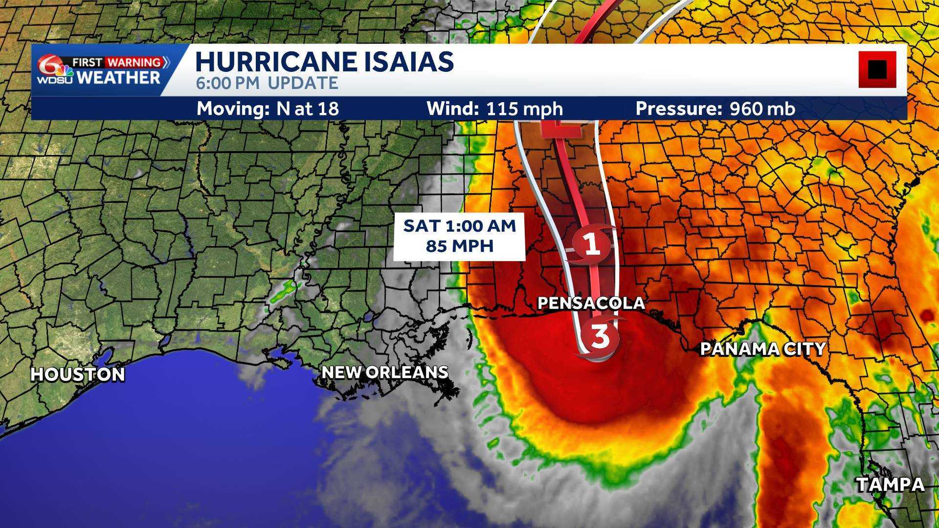
Hurricane Isaias is maintaining hurricane-force winds as it nears landfall in Florida.
The dangerous storm is traveling at a rate of 17 mph and currently has sustained winds of 115 mph.
Landfall is expected near Pensacola or Navarre, Florida by 8 p.m.
Summary: Hurricane Isaias has strengthened into a major Category 3 hurricane as it approaches the northern Gulf Coast. Life-threatening storm surge, damaging winds and heavy rain are expected in the hardest-hit areas. Parts of southeast Louisiana remain under tropical storm and storm surge warnings.
Hurricane Isaias is moving toward the northern Gulf Coast, where landfall is expected late Friday or early Saturday, October 9-10. Coastal Alabama and the Florida Panhandle are at greatest risk of the storm’s strongest impacts, although a shift in the track could change which communities experience the worst conditions.
Isaias has strengthened into a Category 3 hurricane with maximum sustained winds of 120 mph, according to the National Hurricane Center.
A Category 3 hurricane has sustained winds of 111 to 129 mph and is considered a major hurricane.
Friday is a WDSU First Warning Weather Alert Day, mainly because of strong winds and coastal flooding in eastern and coastal portions of southeast Louisiana.
Latest Hurricane Isaias advisory
As of 2 p.m. Friday, October 9:
- Maximum sustained winds: 120 mph
- Movement: NNE at 17 mph
- Location: 150 miles south of Pensacola
- Minimum central pressure: 959 millibars
- Category: 3 — Major Hurricane
Isaias has strengthened while moving over very warm Gulf waters. However, stronger upper-level winds could bring some weakening before landfall.
The hurricane is expected to remain dangerous as it approaches the coast. Its wind field could also expand, bringing gusty winds farther inland.
Local watches and warnings
Tropical Storm Warnings and Storm Surge Warnings are in effect for these southeast Louisiana forecast zones:
- Lower Plaquemines
- Lower St. Bernard
- Eastern Orleans
- Southeast St. Tammany
These warnings cover specific portions of the parishes, not every community.
In Mississippi, Tropical Storm Warnings include Hancock and Harrison counties and inland Jackson County. A Hurricane Warning covers coastal Jackson County, with a Hurricane Watch also in effect for northern Jackson County.
The broader Hurricane Warning extends from Ocean Springs, Mississippi, to the Bay/Gulf County line in Florida.
A Storm Surge Warning extends from the mouth of the Mississippi River eastward along much of the Florida Gulf Coast.
What southeast Louisiana can expect
The main impacts from Hurricane Isaias are expected Friday and Friday night, especially in eastern and coastal communities.
Most inland locations will be spared the hurricane’s strongest conditions, but residents can expect breezy to windy weather as Isaias approaches.
Inland areas could see gusts of 25 to 40 mph, with stronger gusts possible closer to the coast. Some of the most exposed coastal communities could see gusts of 45 to 65 mph.
Areas near Lake Catherine, Slidell, coastal St. Bernard Parish and lower Plaquemines Parish should pay close attention to changing conditions.
A few showers and isolated downpours are possible, especially across eastern portions of the area.
Rain chances will be much lower farther west. Some communities west of Interstate 55 may see little or no rain.
Conditions should begin improving Saturday as Isaias moves away. Sunday is expected to be dry.
Rain and flooding
The heaviest rainfall is expected east of southeast Louisiana, particularly across southern Alabama, the Florida Panhandle and parts of southwestern Georgia.
Rainfall totals of 4 to 8 inches are possible in those areas, with isolated totals up to 15 inches.
Flash flooding, street flooding and river flooding are concerns in the hardest-hit locations.
For southeast Louisiana, the greatest rain chances will be near the Mississippi state line and along the eastern coast.
Not every community will experience heavy rainfall.
Storm surge
Storm surge remains one of the biggest dangers from Hurricane Isaias.
Forecast water levels above normally dry ground include:
- Mississippi River mouth to Ocean Springs: 3–5 feet
- Ocean Springs to Indian Pass, Florida, including Mobile Bay: 5–7 feet
- Indian Pass to Steinhatchee River, Florida: 4–6 feet
These numbers represent potential water levels somewhere within each listed area if peak storm surge occurs around high tide.
Water levels can vary greatly from one community to another. Locations outside hurricane-force winds can still experience dangerous coastal flooding.
Residents in flood-prone coastal communities should follow guidance from local officials and obey evacuation orders.
Wind and wind shear
Damaging hurricane-force winds are expected across portions of southern Mississippi, southern Alabama and the Florida Panhandle.
VIDEO: Conditions rapidly deteriorate in Gulf Shores, Alabama:
These winds could knock down trees, damage buildings and cause power outages that last for several days or longer in the hardest-hit areas.
Although increasing wind shear could weaken Isaias before landfall, the storm could become larger as it approaches the northern Gulf Coast.
That means strong wind gusts may reach communities far from the hurricane’s center.
Tornado concerns
Isolated tornadoes are possible Friday night across coastal Alabama, the Florida Panhandle and far southwestern Georgia.
The tornado threat could spread farther inland Saturday across portions of Alabama, Georgia and northern Florida.
What to do Friday
Residents should now shelter in place as conditions deteriorate across the Gulf Coast, especially those living in warned areas.
Avoid driving through flooded roadways, especially in low-lying coastal communities.
The WDSU First Warning Weather Team will continue tracking Hurricane Isaias and providing updates as the storm approaches landfall.
Related links:
READ MORE:Hurricane Isaias eyewall now approaching the Gulf Coast