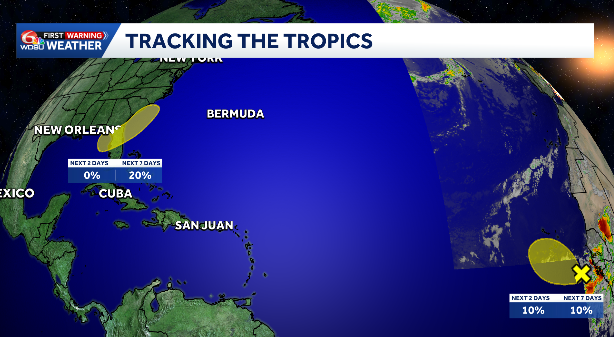
NORTHEASTERN GULF:
An area of low pressure is expected to form during the weekend over the northeastern Gulf. Slow development of this system is possible while it moves slowly northeastward over the northeastern Gulf and/or near the southeastern coast of the United States by early next week.
WHAT WE KNOW:
- Development over the next 2 days: Low, 0%.
- Development over the next 3-7 days: Low, 20%.
IMPACTS TO LOUISIANA:
- We could see a few showers and storms from this over the weekend, but as of now, it does not look like a washout.
- Most models keep a chunk of the rain more for Florida
- Increased rain chances are likely on the east side of the system and drier on the west side.
EASTERN TROPICAL ATLANTIC:
Showers and thunderstorms associated with a tropical wave southeast of the Cabo Verde Islands have become a little better organized during the past 24 hours. Some additional slow development is possible over the next couple of days as the system moves generally west-northwestward. After that, the system is expected to move into an environment that is not conducive for additional development by the weekend.
WHAT WE KNOW:
- Development over the next 2 days: Low, 10%.
- Development over the next 3-7 days: Low, 10%.
IMPACTS TO LOUISIANA:
- None.
READ MORE:Tracking the tropics: Two areas of interest being watched including one near Florida





