The national Weather Service now confirms at least 8 tornadoes touched down on Thursday June 18th, with the possibility of more being added on Monday, with more damage being observed this weekend. None of the tornadoes were stronger than an EF1.
These are the official reports of each tornado according to The National Weather Service.
Tornado #1…
Rating: EF1
Estimated Peak Wind: 90 mph
Path Length /statute/: 0.12 miles
Path Width /maximum/: 40 yards
Fatalities: 0
Injuries: 0
Start Date: 06/18/2026
Start Time: 02:49 AM CDT
Start Location: 2 SSW Houma / Terrebonne Parish / LA
Start Lat/Lon: 29.5439 / -90.7202
End Date: 06/18/2026
End Time: 05:21 PM CDT
End Location: 2 SSW Houma / Terrebonne Parish / LA
End Lat/Lon: 29.5449 / -90.7186
Survey Summary:
A NWS survey team observed two homes on Crozier Drive that had
significant roof loss and at least one exterior wall collapsed
for both homes. The track likely extended further southwest and
northeast but marshy areas restricted access.
Tornado #2…
Rating: EF0
Estimated Peak Wind: 85 mph
Path Length /statute/: 0.10 miles
Path Width /maximum/: 0 yards
Fatalities: 0
Injuries: 0
Start Date: 06/18/2026
Start Time: 03:02 AM CDT
Start Location: 1 ESE Houma / Terrebonne Parish / LA
Start Lat/Lon: 29.5729 / -90.6842
End Date: 06/18/2026
End Time: 03:05 AM CDT
End Location: 1 E Houma / Terrebonne Parish / LA
End Lat/Lon: 29.5743 / -90.6846
Survey Summary:
A NWS survey team concluded an EF-0 tornado produced damage to
trees, several homes, and several electrical wooden poles in the
McCord area of Houma.
Tornado #3…
Rating: EF1
Estimated Peak Wind: 95 mph
Path Length /statute/: 0.10 miles
Path Width /maximum/: 0 yards
Fatalities: 0
Injuries: 0
Start Date: 06/18/2026
Start Time: 03:47 AM CDT
Start Location: 1 ENE Houma / Terrebonne Parish / LA
Start Lat/Lon: 29.5844 / -90.6895
End Date: 06/18/2026
End Time: 03:51 AM CDT
End Location: 1 ENE Houma / Terrebonne Parish / LA
End Lat/Lon: 29.5838 / -90.6881
Survey Summary:
A NWS survey team concluded that an EF-1 tornado tracked from the
corner of Afton St and Richmond Ave towards Dixie Ave in Houma. A
truck was tossed 30 feet and sustained significant damage.
Multiple snapped and uprooted trees were common. Several homes
sustained a partial loss of their roofs. ne home had a collapsed
carport.
Tornado #4…
Rating: EF1
Estimated Peak Wind: 95 mph
Path Length /statute/: 0.96 miles
Path Width /maximum/: 0 yards
Fatalities: 0
Injuries: 0
Start Date: 06/18/2026
Start Time: 03:47 AM CDT
Start Location: 2 ENE Houma / Terrebonne Parish / LA
Start Lat/Lon: 29.5872 / -90.6771
End Date: 06/18/2026
End Time: 03:51 AM CDT
End Location: 1 E Houma / Terrebonne Parish / LA
End Lat/Lon: 29.5774 / -90.6883
Survey Summary:
A NWS survey team concluded an EF-1 tornado tracked from Evelyn
Ave towards Woodhaven Dr and Roberta Grove Blvd. Several
businesses in the Lynn Park Shopping Center (at the corner of
Prospect Ave and Grand Caillou Rd) sustained damage to almost
every window and had partially collapsed interior walls and their
roof. HVAC equipment on the roof was thrown northward onto the
ground from these businesses. 4 homes had partial to significant
roof loss. One home had an exterior wall collapsed. Several
carports were significantly damaged.
Tornado #5…
Rating: EF0
Estimated Peak Wind: 90 mph
Path Length /statute/: 0.44 miles
Path Width /maximum/: 75 yards
Fatalities: 0
Injuries: 2
Start Date: 06/18/2026
Start Time: 05:33 AM CDT
Start Location: 2 WNW Avondale / Jefferson Parish / LA
Start Lat/Lon: 29.912 / -90.216
End Date: 06/18/2026
End Time: 05:34 AM CDT
End Location: 1 NW Avondale / Jefferson Parish / LA
End Lat/Lon: 29.9158 / -90.2102
Survey Summary:
A brief tornado touched down north of Highway 90 in Avondale, LA.
It tracked northeast with the majority of the damage being light
home damage and snapped tree branches. The house with the most
damage received that damage from another mobile home being rolled
into it. The rest of that home was thrown to the northeast with
the frame being well bent.
Tornado #6…
Rating: EF1
Estimated Peak Wind: 95 mph
Path Length /statute/: 7.26 miles
Path Width /maximum/: 0 yards
Fatalities: 0
Injuries: 0
Start Date: 06/18/2026
Start Time: 05:43 AM CDT
Start Location: 2 NNE Bridge City / Jefferson Parish / LA
Start Lat/Lon: 29.9603 / -90.1468
End Date: 06/18/2026
End Time: 05:59 AM CDT
End Location: 4 NNE New Orleans / Orleans Parish / LA
End Lat/Lon: 30.0329 / -90.0592
Survey Summary:
An EF1 tornado touched down on the east bank of the MS River and
moved northeast to the University of New Orleans. Damage across
the city was mostly tree damage and minor building damage.
Additional analysis, points and information will be added later.
Additional changes are possible.
Tornado #7…
Rating: EF1
Estimated Peak Wind: 105 mph
Path Length /statute/: 12.42 miles
Path Width /maximum/: 300 yards
Fatalities: 0
Injuries: 0
Start Date: 06/18/2026
Start Time: 06:59 AM CDT
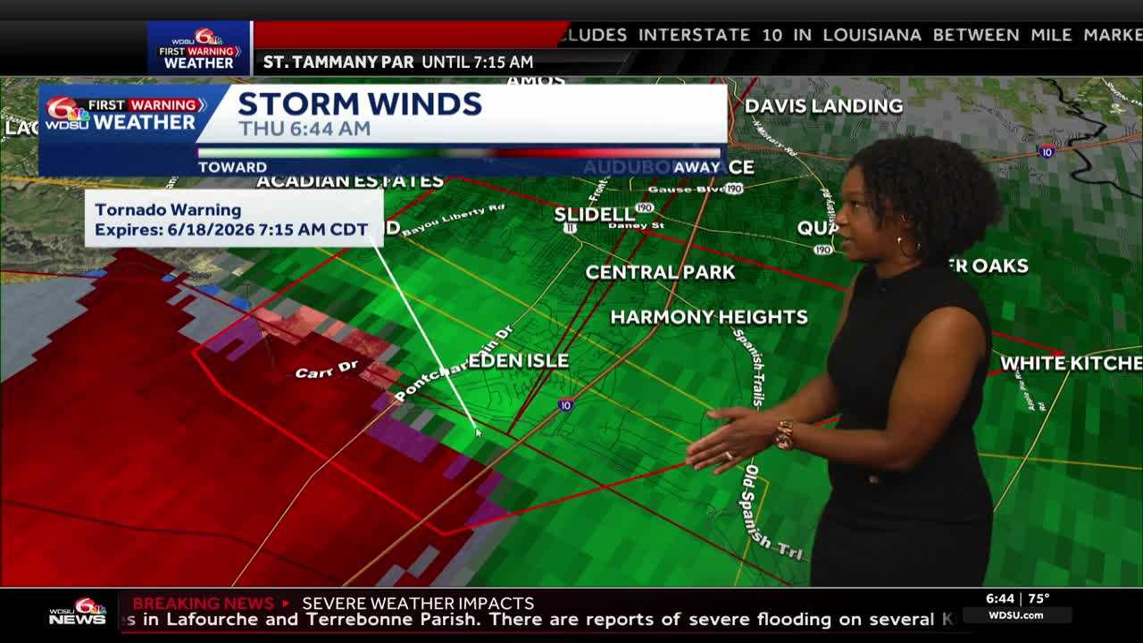
Start Location: 4 SE Eden Isle / St. Tammany Parish / LA
Start Lat/Lon: 30.1845 / -89.7564
End Date: 06/18/2026
End Time: 07:15 AM CDT
End Location: 3 N Pearlington / Hancock County / MS
End Lat/Lon: 30.2957 / -89.6005
Survey Summary:
NWS ground survey confirmed an EF-1 tornado with maximum
sustained winds of 105 mph tracked from Treasure Isle in
southeast St. Tammany Parish to rural parts of southwest Hancock
County, north of Pearlington. The tornado began near or before
moving into Treasure Isle where it flipped a large boat on it
side. Additional visible damage to homes and lofting of outdoor
fixtures was noted as the tornado moved into Martin Drive. The
tornado reached EF-1 intensity near Bluegill Drive where it
removed shingles off of homes, snapped a few trees, and collapsed
garage door structures and blew out a wall or two as a result in
two different homes. A defined damage path was observed on LA Hwy
433 and then crossed into inaccessible marsh areas. A weak tornado
debris signature was evident on KHDC and is the basis for
connecting this damage to Avery Estates. The tornado continued
northeast into Avery Estates where minor metal roof damage and
tree damage was noted on Avery Drive and Smokey Hollow Drive. The
tornado evidently strengthened and grew in size to around
300 yards in width as it moved just south of the northern part of
Avery Drive and into US Hwy 190 where numerous trees were
uprooted or snapped. Several outbuildings were damaged and
tension cables on a cell tower were snapped. It`s possible the
tornado slowed in this area as it pivoted and turned more to the
east per KHDC radar imagery. Along US Hwy 190 a manufactured home
had most of its roof removed and it was shifted significantly off
its foundation. The tornado then moved into Pearl River Basin,
inaccessible to ground survey. The tornado evidently maintained
strength or even strengthened further over this area, evidenced
by the deepening of a tornado debris signature lofted over
5000 feet. Tree damage was found by ground survey team on rural
roads of southwest Hancock County as the tornado began to weaken
and lift back to the northeast. The tornado is estimated to have
lifted near or after Point Road prior to reaching MS Hwy 607.
Tornado #8…
Rating: EF1
Estimated Peak Wind: 90 mph
Path Length /statute/: 6.38 miles
Path Width /maximum/: 0 yards
Fatalities: 0
Injuries: 0
Start Date: 06/18/2026
Start Time: 08:01 AM CDT
Start Location: 8 NE Kiln / Hancock County / MS
Start Lat/Lon: 30.5084 / -89.3454
End Date: 06/18/2026
End Time: 08:12 AM CDT
End Location: 9 WSW Saucier / Harrison County / MS
End Lat/Lon: 30.5757 / -89.2767
Survey Summary:
A NWS survey team concluded that an EF-1 tornado tracked
northeast across Hancock and Harrison counties. Tree damage was
widespread along the track including several large trees uprooted
and snapped. Minor damage was done to several properties. The
tornado likely continued further northeast since the survey team
was limited by flooded roadways and heavily forested areas.
READ MORE:National Weather Service now confirms eight tornadoes June 18th


