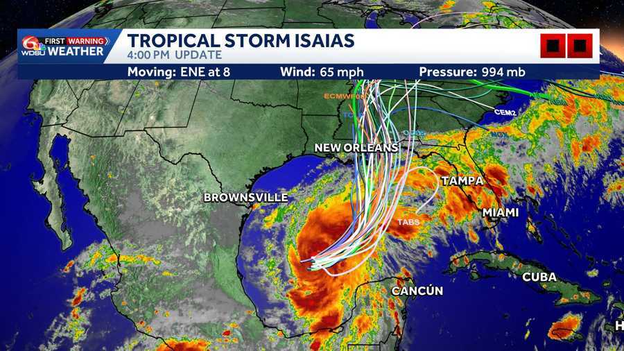
Tropical Storm Isaias track has shifted more east and the storm is gaining strength.
CLICK HERE to make WDSU a preferred news source on Google.
The system is expected to drift eastward before turning north or northeast toward the northern Gulf Coast by the end of the week. Areas being closely watched include the Louisiana coast to the Florida Panhandle.
The National Hurricane Center expects Isaias to become a hurricane by Thursday and approach the northern Gulf Coast Friday.
A Hurricane Watch is in effect for Bay St. Louis, Mississippi to Indian Pass, Florida.
A Tropical Storm Watch is in effect for the Jefferson Parish, Plaquemines Parish line to Bay St. Louis, and east of Indian Pass to Aucilla River, Florida.
A Storm Surge Watch is in effect for the Mouth of the Mississippi River to Yankeetown, Florida.
Click here to download the WDSU News app
LATEST CONE:
SPAGHETTI MODELS:
A LOOK AT THE ATLANTIC BASIN:
12-HOUR FORECAST
7-DAY FORECAST
SATELLITE VIEW 1
SATELLITE VIEW 2
Tropical Storm, Hurricane watches:
A Hurricane Watch is in effect for Bay St. Louis, Mississippi to Indian Pass, Florida.
A Tropical Storm Watch is in effect for the Jefferson Parish, Plaquemines Parish line to Bay St. Louis, and east of Indian Pass to Aucilla River, Florida.
Storm Surge:
A Storm Surge Watch is in effect for the Mouth of the Mississippi River to Yankeetown, Florida.
Tropical Alert definitions:
A Storm Surge Watch means there is a possibility of life-threatening inundation from rising water.
A Hurricane Watch means that hurricane conditions are possible within the next 48 hours.
A Tropical Storm Watch means that tropical storm conditions are possible within 48 hours.
Heavy rain and flooding possible:
From Friday through the weekend, Isaias could bring 3 to 6 inches of rain, with localized totals up to 10 inches, across parts of the northern Gulf Coast from far southeastern Louisiana to the Florida Panhandle.
Those amounts are a regional forecast and do not mean every community will receive that much rain. The storm’s track will help determine where the heaviest rainfall develops.
Flash flooding, street flooding and isolated river flooding will be possible.
Dangerous surf and rip currents are also expected along the Gulf Coast late this week.
What to know locally:
Friday and Saturday are WDSU First Warning Alert Days because of the potential for significant weather impacts.
The storm’s track and strength will determine local conditions. Residents should review their hurricane plans, check supplies and follow updates from WDSU First Warning Weather and the National Hurricane Center.
The next complete NHC advisory is scheduled for 10 a.m. Wednesday.
Hurricane Hunters are expected to investigate the system today, providing valuable data that should help refine the forecast.
READ MORE:Tracking Tropical Storm Isaias: Interactive storm radar, latest cone, models and satellite